University of Oregon Environmental Leadership Program
Stream Stewardship 2017

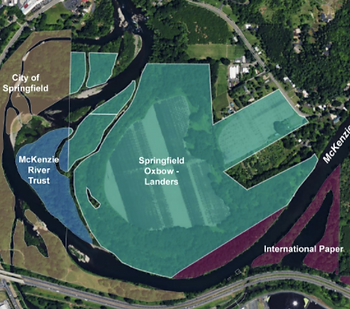
Springfield Oxbow is eight miles east of Eugene along the McKenzie River. It features side channels of the McKenzie that harbor habitat for native fish right above the EWEB water intake. The site is both private and public lands dominated by cottonwood and alder riparian forests, with multiple invasive under-story species. The Landers property covers most of the area and is currently used for farming. Part of the site is also owned by the Mckenzie River Trust. The oxbow has been identified as a priority area for side channel habitat restoration, as it provides calm waters for juvenile salmon and trout species despite being degraded by farming and land-use practices. Our task is to evaluate side channels and map invasive species in order to develop restoration planning and document baseline conditions for the McKenzie Watershed Council.
Located sixty-five miles east of Eugene, Deer Creek is a tributary of the McKenzie River. The location features a complex, dynamic floodplain that harbors habitat for threatened and endangered fish species such as Chinook salmon and bull trout. Historically, the natural floodplain has suffered from riparian logging and stream channelization, which is not ideal for the health and well being of native fish populations. Stream stewardship teams have been assisting with monitoring since the project began in 2016. Our goal this year is to provide data that will show the effectiveness of this project, which will help guide the large-scale floodplain restoration project on the South Fork McKenzie.
Study Sites & Methods
Methods
Our work at Springfield Oxbow involved mapping side channels on the ground with the help of GPS units. Measurements were taken every 50 meters, including width and depth of the channel, and height of the bank. Number of pools and their maximum depth was also recorded.
We also mapped the occurrences of target invasive species, including but not limited to; blackberries, clematis, English ivy and holly. Locations were recorded using GPS waypoints for instances of some species and GPS tracks for larger plots of other species.
These data were then used to create maps for presentation to McKenzie Watershed Council along with our management recommendations.
At Deer Creek, our team took measurements along transects provided to us by the US Forest Service and McKenzie Watershed Council.
23 transects spanning the creek were spaced roughly 50 meters apart along the restoration area. Along each transect, our team counted separate channels, classified substrate, measured water temperature and velocity, counted large wood and evaluated riparian communities on each bank.
Our work at Deer Creek will provide the Forest Service and McKenzie Watershed Council with valuable data that will show how effective restoration work was at restoring stream function. These data will be presented to both agencies along with our recommendations for future managment.
Springfield Oxbow:
Deer Creek: